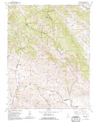
1991 Map of Tassajara
USGS Topo · Published 1995About this map
The Black Hills dominate this section of the Diablo Range, where the boundary between Contra Costa and Alameda counties follows the ridgelines and canyon floors. The landscape is defined by its educational and ranching history, evidenced by the presence of Tassajara Sch and Highland Sch, both marked as abandoned by the early 1990s. These former school sites sit near critical rural arteries like Tassajara Road and Highland Road, which historically connected the scattered homesteads of the interior valleys.
Find a feature on this map
32 named features on this map. Tap any name to fly to it.
Don’t see what you’re looking for? This feature index may not catch every label — zoom into the map to look around manually.
Map Details
Editions of this 1991 Tassajara Map
This is the sole edition of this map. No revisions or reprints were ever made.
Other maps of this area

1896 · Mt. Diablo
USGS Topo · 1:62,500

1898 · Mt. Diablo
USGS Topo · 1:62,500

1906 · Pleasanton
USGS Topo · 1:62,500

1907 · Tesla
USGS Topo · 1:62,500

1911 · Byron Hot Springs
USGS Topo · 1:31,680

1914 · Brentwood
USGS Topo · 1:31,680

1916 · Lone Tree Valley
USGS Topo · 1:31,680

1916 · Byron Hot Springs
USGS Topo · 1:31,680

1916 · Byron
USGS Topo · 1:62,500

1940 · Byron
USGS Topo · 1:62,500