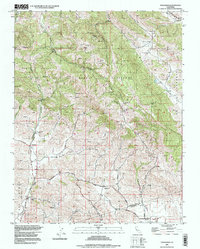
1996 Map of Tassajara
USGS Topo · Published 1999About this map
The Black Hills and Morgan Territory dominate this terrain on the southern edge of Mount Diablo State Park, revealing a landscape where ranching roots and early education centers once flourished. The map identifies specific evidence of a fading rural infrastructure through entries like the Tassajara Sch (Abandoned) and Highland Sch (Abandoned), pointing to former community nodes along the winding creek beds and canyon floors.
Find a feature on this map
34 named features on this map. Tap any name to fly to it.
Don’t see what you’re looking for? This feature index may not catch every label — zoom into the map to look around manually.
Map Details
Editions of this 1996 Tassajara Map
This is the sole edition of this map. No revisions or reprints were ever made.
Other maps of this area

1896 · Mt. Diablo
USGS Topo · 1:62,500

1898 · Mt. Diablo
USGS Topo · 1:62,500

1906 · Pleasanton
USGS Topo · 1:62,500

1907 · Tesla
USGS Topo · 1:62,500

1911 · Byron Hot Springs
USGS Topo · 1:31,680

1914 · Brentwood
USGS Topo · 1:31,680

1916 · Lone Tree Valley
USGS Topo · 1:31,680

1916 · Byron Hot Springs
USGS Topo · 1:31,680

1916 · Byron
USGS Topo · 1:62,500

1940 · Byron
USGS Topo · 1:62,500