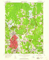
1949 Map of Taunton
USGS Topo · Published 1960About this map
Taunton serves as the dense industrial and civic hub of this post-war landscape, situated at the head of the Taunton River. The city's mid-century footprint is marked by prominent institutions such as the Taunton Insane Hospital and the Coyle High Sch, while the surrounding geography is defined by a complex network of wetlands and water bodies. To the north, the massive Hockomock Swamp dominates the terrain, feeding into the Hockomock River and Lake Nippenicket.
Find a feature on this map
100 named features on this map. Tap any name to fly to it.
Don’t see what you’re looking for? This feature index may not catch every label — zoom into the map to look around manually.
Map Details
Editions of this 1949 Taunton Map
2 editions found

Other maps of this area

1885 · Abington
USGS Topo · 1:62,500

1885 · Middleboro
USGS Topo · 1:62,500

1885 · Taunton
USGS Topo · 1:62,500

1886 · Dedham
USGS Topo · 1:62,500

1888 · Taunton
USGS Topo · 1:62,500

1888 · Middleboro
USGS Topo · 1:62,500

1888 · Abington
USGS Topo · 1:62,500

1893 · Abington
USGS Topo · 1:62,500

1893 · Taunton
USGS Topo · 1:62,500

1893 · Middleboro
USGS Topo · 1:62,500