
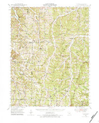
1948 Map of Tavern
USGS Topo · Published 1973About this map
The Maries River and Tavern Creek carve a deeply etched landscape through Maries County in this mid-century survey. This rural district is defined by a dense network of one-room schoolhouses and country churches, reflecting a decentralized settlement pattern before the consolidation of the late 20th century. Notable gathering points like Brinktown, Old Van Cleve, and Meyers Town anchor the local community, while the presence of an Underground Pipe Line cutting across the terrain signals the arrival of industrial infrastructure. Family history is preserved in numerous burial grounds, including the Barnhart Cem and Pendleton Cem. The topography is particularly detailed around Spring Valley Lake and the winding course of Little Tavern Creek, providing a clear record of the area's drainage and land use during the post-war era.
Find a feature on this map
67 named features on this map. Tap any name to fly to it.
Don’t see what you’re looking for? This feature index may not catch every label — zoom into the map to look around manually.
Map Details
Editions of this 1948 Tavern Map
2 editions found
Other maps of this area

1888 · Tuscumbia
USGS Topo · 1:125,000

1894 · Tuscumbia
USGS Topo · 1:125,000

1912 · Rolla
USGS Topo · 1:62,500

1933 · Iberia
USGS Topo · 1:62,500

1934 · Linn
USGS Topo · 1:48,000

1936 · Waynesville
USGS Topo · 1:48,000

1937 · Iberia
USGS Topo · 1:62,500

1937 · Vienna
USGS Topo · 1:62,500

1938 · Vienna
USGS Topo · 1:48,000

1942 · Waynesville
USGS Topo · 1:62,500