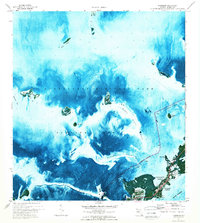
1971 Map of Tavernier
USGS Topo · Published 1973About this map
Florida Bay dominates this orthophotomap, showing the intricate network of shoals and keys that define the transition between the mainland and the open sea in the early 1970s. The settlement of Tavernier serves as the focal point of human activity, situated along the coastal corridor where the Burton Memorial United Ch and Tavernier Harbor are located. This hybrid map combines aerial imagery with traditional topographic survey data, providing a unique look at the shallow-water environment where Everglades National Park boundaries meet the managed channels of the Intracoastal Waterway. To the west, the map reveals the natural structure of Upper Cross Bank and Ramshorn Shoal, while the smaller mangrove islands like Bottle Key, Pigeon Key, and the Bob Keys stand out against the varying depths of the submerged flats.
Find a feature on this map
30 named features on this map. Tap any name to fly to it.
Don’t see what you’re looking for? This feature index may not catch every label — zoom into the map to look around manually.
Map Details
Editions of this 1971 Tavernier Map
2 editions found
Other maps of this area

1947 · Rock Harbor
USGS Topo · 1:24,000

1947 · Blackwater Sound
USGS Topo · 1:24,000

1949 · Blackwater Sound
USGS Topo · 1:24,000

1949 · Rock Harbor
USGS Topo · 1:24,000

1956 · Miami
USGS Topo · 1:250,000

1958 · Miami
USGS Topo · 1:250,000

1971 · Upper Matecumbe Key
USGS Topo · 1:24,000

1971 · Tavernier
USGS Topo · 1:24,000

1971 · Plantation Key
USGS Topo · 1:24,000

1972 · Madeira Bay
USGS Topo · 1:24,000