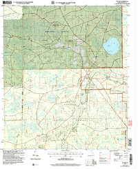
2005 Map of Taylor
USGS Topo · Published 2006About this map
Osceola National Forest and the John M Bethea State Forest define this landscape on the Florida-Georgia border, characterized by an intricate network of wetlands and bayous. The map captures the quiet intersection of forest management and rural settlement at Taylor, where Pine Grove Ch, Pine Grove Cem, and Pleasant Grove Ch serve as focal points for local genealogy and history. The terrain is a mosaic of named swamps and "bays," including Pinhook Swamp, Cattail Bay, and Ocean Bay, which feed the headwaters of the St Marys River. Notable family-named landmarks such as Huckleberry Island, Dog Island, and Raulerson Road indicate the deep-rooted local history within these timberlands. The hydrological pattern of the Middle Prong St Marys River and East Prong St Marys River reveals how the drainage of the swamp dictated the placement of early forest roads and fire towers like the East Tower Hunt Camp.
Find a feature on this map
39 named features on this map. Tap any name to fly to it.
Don’t see what you’re looking for? This feature index may not catch every label — zoom into the map to look around manually.
Map Details
Editions of this 2005 Taylor Map
This is the sole edition of this map. No revisions or reprints were ever made.
Other maps of this area

1917 · Macclenny
USGS Topo · 1:62,500

1918 · Moniac
USGS Topo · 1:62,500

1918 · Macclenny
USGS Topo · 1:62,500

1942 · Moniac
USGS Topo · 1:62,500

1954 · Valdosta
USGS Topo · 1:250,000

1956 · Eddy
USGS Topo · 1:24,000

1956 · Sargent
USGS Topo · 1:24,000

1958 · Valdosta
USGS Topo · 1:250,000

1959 · Valdosta
USGS Topo · 1:250,000
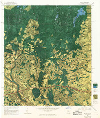
1967 · Moniac
USGS Topo · 1:24,000