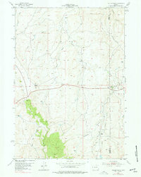
1954 Map of Taylor Ranch
USGS Topo · Published 1977About this map
The historic Bozeman Trail cuts across this high plains landscape, marking a vital 19th-century corridor for emigrants and gold seekers heading toward Montana. The map centers on the winding course of the Dry Fork Powder River, where the terrain is defined by a dense network of drainages including Lone Tree Draw, Crawford Draw, and Davis Draw.
Find a feature on this map
21 named features on this map. Tap any name to fly to it.
Don’t see what you’re looking for? This feature index may not catch every label — zoom into the map to look around manually.
Map Details
Editions of this 1954 Taylor Ranch Map
2 editions found
Other maps of this area

1953 · Dry Fork Ranch
USGS Topo · 1:24,000

1953 · Rolling Pin Ranch
USGS Topo · 1:24,000

1954 · House Creek
USGS Topo · 1:24,000

1954 · Artesian Draw
USGS Topo · 1:24,000

1954 · Linch
USGS Topo · 1:24,000

1954 · Taylor Ranch
USGS Topo · 1:24,000

1955 · Newcastle
USGS Topo · 1:250,000

1955 · Arminto
USGS Topo · 1:250,000

1958 · Arminto
USGS Topo · 1:250,000

1958 · Newcastle
USGS Topo · 1:250,000