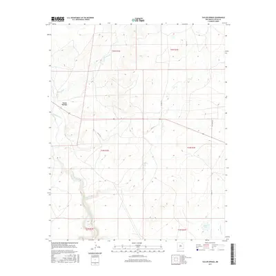
2017 Map of Taylor Springs
USGS Topo · Published 2017About this map
Taylor Springs sits at the northern edge of a landscape defined by the winding course of the Canadian River and its seasonal tributaries. This high plains region of Colfax County is marked by the historical path of the Santa Fe Trl, which cuts across the terrain as a reminder of early western expansion and trade routes. The drainage patterns of Alkali Arroyo and Chico Cr converge toward the river valley, illustrating the erosion-carved topography typical of the New Mexico steppe.
Find a feature on this map
16 named features on this map. Tap any name to fly to it.
Don’t see what you’re looking for? This feature index may not catch every label — zoom into the map to look around manually.
Map Details
Editions of this 2017 Taylor Springs Map
This is the sole edition of this map. No revisions or reprints were ever made.
Other maps of this area
1954 · Raton
USGS Topo · 1:250,000
1958 · Raton
USGS Topo · 1:250,000
1964 · Stony Lake
USGS Topo · 1:24,000
1965 · Sauble Circle Dot Ranch
USGS Topo · 1:24,000
1965 · Abbott NW
USGS Topo · 1:24,000
1965 · French
USGS Topo · 1:24,000
1965 · Taylor Springs
USGS Topo · 1:24,000
1965 · Abbott
USGS Topo · 1:24,000
1965 · Springer
USGS Topo · 1:24,000
1971 · Abbott Lake
USGS Topo · 1:24,000