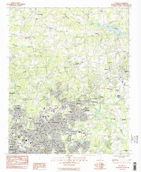
1983 Map of Taylors
USGS Topo · Published 1983About this map
The Enoree River and Tyger River headwaters define this landscape on the outskirts of Greenville, where suburban expansion meets rural history. In the early 1980s, the area around Taylors and Chick Springs shows a dense network of neighborhood developments like Cherokee Forest and Hampton Heights pressing against established landmarks. The presence of the Southern Bleachery near the Southern Railway tracks points to the region's textile heritage, while the State Dept of Corrections and a Franciscan Monastery occupy significant plots near Paris.
Find a feature on this map
78 named features on this map. Tap any name to fly to it.
Don’t see what you’re looking for? This feature index may not catch every label — zoom into the map to look around manually.
Map Details
Editions of this 1983 Taylors Map
This is the sole edition of this map. No revisions or reprints were ever made.
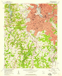
Other maps of this area

1907 · Saluda
USGS Topo · 1:125,000

1935 · Greer
USGS Topo · 1:48,000

1935 · Greenville
USGS Topo · 1:48,000

1938 · Greenville
USGS Topo · 1:62,500

1938 · Greer
USGS Topo · 1:62,500

1954 · Greenville
USGS Topo · 1:250,000

1955 · Knoxville
USGS Topo · 1:250,000
1957 · Greenville
USGS Topo · 1:24,000

1957 · Greer
USGS Topo · 1:62,500

1957 · Greenville
USGS Topo · 1:62,500