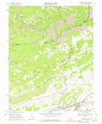
1968 Map of Tazewell North
USGS Topo · Published 1977About this map
The industrial and mountain landscapes of the Virginia-West Virginia border are captured here during a period of intensive coal extraction. Large-scale extractive operations, including numerous Strip Mine sites and a tipple, dominate the northern terrain near Squire and Bishop. This mining activity is served by the Norfolk and Western railroad, which threads through the steep valleys. To the south, the landscape shifts toward the more settled corridor of Tazewell and North Tazewell, located along the Clinch River. Local life is visible through landmarks like the Bishop Sch and Maplewood Cem, alongside rural crossroads such as Adria and Sayersville. The map illustrates the topographical divide between the coalfields of McDowell Co and the agricultural and residential areas along Stony Ridge and Baptist Valley.
Find a feature on this map
59 named features on this map. Tap any name to fly to it.
Don’t see what you’re looking for? This feature index may not catch every label — zoom into the map to look around manually.
Map Details
Editions of this 1968 Tazewell North Map
2 editions found
Other maps of this area

1887 · Pocahontas
USGS Topo · 1:125,000

1891 · Tazewell
USGS Topo · 1:125,000

1891 · Pocahontas
USGS Topo · 1:125,000

1894 · Pocahontas
USGS Topo · 1:125,000

1895 · Tazewell
USGS Topo · 1:125,000

1895 · Pocahontas
USGS Topo · 1:125,000

1897 · Tazewell
USGS Topo · 1:125,000

1909 · Pocahontas Special
USGS Topo · 1:48,000

1911 · Pocahontas Special
USGS Topo · 1:62,500

1912 · Pounding Mill
USGS Topo · 1:62,500