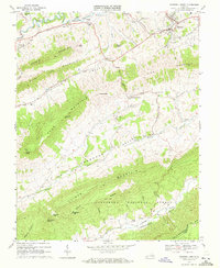
1968 Map of Tazewell South
USGS Topo · Published 1972About this map
Wittens Fort stands as a significant historical marker in the northern section of this landscape, situated near the Clinch River and the village of Pisgah. The terrain is defined by a series of prominent ridges, including Deskin Mountain and Rich Mountain, which channel settlement and transit through fertile valleys like Freestone Valley and Little Valley. This 1960s environment shows a distinct network of rural communities such as Frog Level and Maiden, connected by mountain gaps and winding roads.
Find a feature on this map
52 named features on this map. Tap any name to fly to it.
Don’t see what you’re looking for? This feature index may not catch every label — zoom into the map to look around manually.
Map Details
Editions of this 1968 Tazewell South Map
2 editions found
Other maps of this area

1887 · Pocahontas
USGS Topo · 1:125,000

1889 · Wytheville
USGS Topo · 1:125,000

1891 · Tazewell
USGS Topo · 1:125,000

1891 · Pocahontas
USGS Topo · 1:125,000

1891 · Abingdon
USGS Topo · 1:125,000

1892 · Wytheville
USGS Topo · 1:125,000

1894 · Pocahontas
USGS Topo · 1:125,000

1894 · Abingdon
USGS Topo · 1:125,000

1895 · Tazewell
USGS Topo · 1:125,000

1895 · Pocahontas
USGS Topo · 1:125,000