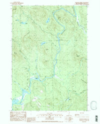
1988 Map of Teakettle Ridge
USGS Topo · Published 1988About this map
The Androscoggin River carves a deep path through Coos County, defining the boundaries of Errol, Millsfield, Dummer, and Cambridge. This high-country landscape is dominated by the sprawling Teakettle Ridge and peaks like Double Top Mountain and Cow Mountain. The river itself is the central artery for both recreation and industry, flowing through the protected Thirteen Mile Woods Scenic Area and into the Pontook Reservoir. Unique river features such as Seven Islands and Wentworth Island appear alongside remnants of local resource extraction, including a Gravel Pit near the riverbank. Numerous high-elevation water bodies like Moose Pond, Sessions Pond, and Munn Pond suggest a rugged geography where glacial activity left behind a complex network of brooks and still water, providing a detailed look at this timberland region in the late 1980s.
Find a feature on this map
37 named features on this map. Tap any name to fly to it.
Don’t see what you’re looking for? This feature index may not catch every label — zoom into the map to look around manually.
Map Details
Editions of this 1988 Teakettle Ridge Map
2 editions found
Other maps of this area

1930 · Milan
USGS Topo · 1:62,500

1930 · Percy
USGS Topo · 1:62,500

1930 · Dixville
USGS Topo · 1:62,500

1930 · Errol
USGS Topo · 1:62,500

1933 · Dixville
USGS Topo · 1:62,500

1933 · Milan
USGS Topo · 1:62,500

1934 · Percy
USGS Topo · 1:62,500

1934 · Dixville
USGS Topo · 1:62,500

1934 · Errol
USGS Topo · 1:62,500

1934 · Milan
USGS Topo · 1:62,500