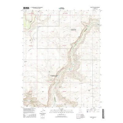
2017 Map of Teapot Rock
USGS Topo · Published 2017About this map
Cataract Canyon dominates this 2017 survey, where the Colorado River carves through the heart of Canyonlands National Park and the Glen Canyon National Recreation Area. The river's power is evident in the marking of Mile Long Rapids and Big Drop Rapids, leading toward the northern reaches of Lake Powell. The map illustrates a landscape of extreme verticality, defined by the Orange Cliffs to the north and numerous side drainages like Teapot Canyon and Gypsum Canyon. Overland access is traced through primitive routes such as the Flint Trail and Doll House Road, which navigate the plateaus above Waterhole Flat. Landmarks like Teapot Rock, The Button, and Ocean Point serve as navigational aids in this complex network of sandstone fins and deep gorges, providing a detailed record of the terrain as it appeared in the early 21st century.
Find a feature on this map
33 named features on this map. Tap any name to fly to it.
Don’t see what you’re looking for? This feature index may not catch every label — zoom into the map to look around manually.
Map Details
Editions of this 2017 Teapot Rock Map
This is the sole edition of this map. No revisions or reprints were ever made.
Other maps of this area

1885 · San Rafael
USGS Topo · 1:250,000
1885 · La Sal
USGS Topo · 1:250,000

1886 · Henry Mountains
USGS Topo · 1:250,000
1886 · Abajo
USGS Topo · 1:250,000
1892 · Abajo
USGS Topo · 1:250,000

1892 · Henry Mountains
USGS Topo · 1:250,000
1893 · Abajo
USGS Topo · 1:250,000
1935 · Elk Ridge
USGS Topo · 1:96,000
1940 · Elk Ridge
USGS Topo · 1:125,000
1952 · Mouth of Dark Canyon
USGS Topo · 1:62,500