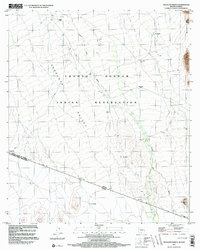
1996 Map of Tecolote Ranch
USGS Topo · Published 2003About this map
The Tohono O'odham Indian Reservation dominates this borderlands landscape, where the Tecolote Valley meets the rugged Alvarez Mountains along the international boundary between the United States of America and Mexico. The map documents a sparse desert environment defined by ephemeral watercourses like Chukut Kuk Wash and remote outposts such as Tecolote Ranch. Genealogists and local historians can locate several former habitation points, including San Rafael (Site) and Vakamok (Site), alongside a small Cemetery near the ranch. The southern edge of the sheet follows the Arizona-Sonora border, marked by a series of survey monuments and 4WD tracks that emphasize the isolation of this high-desert terrain during the late twentieth century. Landforms like Wolfley Hill and El Chango provide distinct topographical markers in an area where resources are centered on features like the San Rafael Well.
Find a feature on this map
37 named features on this map. Tap any name to fly to it.
Don’t see what you’re looking for? This feature index may not catch every label — zoom into the map to look around manually.
Map Details
Editions of this 1996 Tecolote Ranch Map
This is the sole edition of this map. No revisions or reprints were ever made.
Other maps of this area

1941 · Vamori
USGS Topo · 1:62,500

1941 · Sells
USGS Topo · 1:62,500

1943 · Sells
USGS Topo · 1:62,500

1943 · Fresnal
USGS Topo · 1:125,000

1943 · Vamori
USGS Topo · 1:62,500

1954 · Sonoyta
USGS Topo · 1:250,000

1956 · Nogales
USGS Topo · 1:250,000

1958 · Nogales
USGS Topo · 1:250,000

1959 · Nogales
USGS Topo · 1:250,000

1963 · Gu Oidak
USGS Topo · 1:62,500
Featured Places
- Vakamok, Chukut Kuk District
- Chukut Kuk District, AZ
- Tatkum Vo, Chukut Kuk District
- San Rafael, Chukut Kuk District