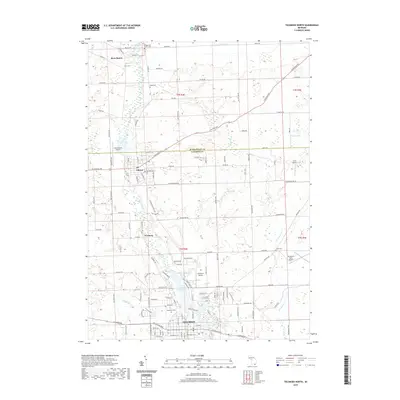
2019 Map of Tecumseh North
USGS Topo · Published 2019About this map
The River Raisin flows south through the center of this Lenawee County landscape, anchoring the settlements of Clinton and Tecumseh. This 2019 survey documents the transition between the developed corridors of the village of Clinton and the northern fringes of Tecumseh, where the river widens at Red Millpond and Standish Pond. The map reveals a high concentration of small aviation facilities, including Honey Acres Airport, Al Meyers Airport, and Carl's Airport, suggesting a unique local heritage of private flight and rural airstrips. Genealogists will find several burial grounds across the township boundaries, from the central Brookside Cem and Old East Cem to the outlying Bridgewater Center Cem and Aten Cem. The terrain is also defined by the convergence of several waterways like Evans Cr and Dillingham Cr, which feed the river system that historically drove the region's industry.
Find a feature on this map
74 named features on this map. Tap any name to fly to it.
Don’t see what you’re looking for? This feature index may not catch every label — zoom into the map to look around manually.
Map Details
Editions of this 2019 Tecumseh North Map
This is the sole edition of this map. No revisions or reprints were ever made.
Other maps of this area

1904 · Ann Arbor
USGS Topo · 1:125,000

1906 · Saline
USGS Topo · 1:62,500

1908 · Ann Arbor
USGS Topo · 1:125,000

1939 · Blissfield
USGS Topo · 1:62,500

1941 · Blissfield
USGS Topo · 1:62,500

1948 · Manchester
USGS Topo · 1:62,500

1949 · Manchester
USGS Topo · 1:62,500

1953 · Fort Wayne
USGS Topo · 1:250,000

1954 · Detroit
USGS Topo · 1:250,000

1956 · Fort Wayne
USGS Topo · 1:250,000