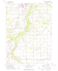
1972 Map of Tecumseh South
USGS Topo · Published 1975About this map
The Raisin River carves a winding path through this portion of Lenawee County, south of the established center of Tecumseh. This early 1970s landscape is defined by its complex industrial and transportation infrastructure, where gravel pits, sandpits, and a Refinery operate alongside the extensive rail networks of the Detroit Toledo and Ironton, Norfolk and Western, and Penn Central. These tracks converge at significant transit points like Lenawee Junction, which served as a vital hub for the regional movement of goods and passengers.
Find a feature on this map
62 named features on this map. Tap any name to fly to it.
Don’t see what you’re looking for? This feature index may not catch every label — zoom into the map to look around manually.
Map Details
Editions of this 1972 Tecumseh South Map
This is the sole edition of this map. No revisions or reprints were ever made.
Other maps of this area

1904 · Ann Arbor
USGS Topo · 1:125,000

1906 · Saline
USGS Topo · 1:62,500

1908 · Ann Arbor
USGS Topo · 1:125,000

1939 · Blissfield
USGS Topo · 1:62,500

1941 · Blissfield
USGS Topo · 1:62,500

1948 · Manchester
USGS Topo · 1:62,500

1949 · Manchester
USGS Topo · 1:62,500

1953 · Fort Wayne
USGS Topo · 1:250,000

1954 · Detroit
USGS Topo · 1:250,000

1956 · Fort Wayne
USGS Topo · 1:250,000