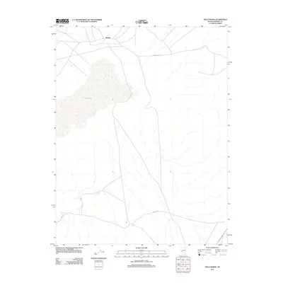
2011 Map of Teels Marsh
USGS Topo · Published 2011About this map
Marietta sits on the northern edge of a desert landscape dominated by the expanse of Teels Marsh. This high-desert region in Mineral County is characterized by its vital water sources, with Rock House Spring, Company Spring, and German Spring providing rare points of relief across the arid terrain. The settlement pattern is defined by the crossroads of Garfield Flat Rd and Marietta Rd, which connect this remote outpost to the broader Nevada backcountry. The map illustrates a stark topography where the salt crust of the marsh meets the surrounding alluvial fans, a geography that has historically supported mining interests in the Great Basin. This survey provides a precise look at the hydrology and rudimentary road network of the area as it appeared in the early 21st century.
Find a feature on this map
8 named features on this map. Tap any name to fly to it.
Don’t see what you’re looking for? This feature index may not catch every label — zoom into the map to look around manually.
Map Details
Editions of this 2011 Teels Marsh Map
This is the sole edition of this map. No revisions or reprints were ever made.
Other maps of this area

1909 · Hawthorne
USGS Topo · 1:250,000

1911 · Hawthorne
USGS Topo · 1:250,000

1915 · Hawthorne
USGS Topo · 1:250,000

1948 · Walker Lake
USGS Topo · 1:250,000

1957 · Walker Lake
USGS Topo · 1:250,000

1962 · Walker Lake
USGS Topo · 1:250,000

1964 · Walker Lake
USGS Topo · 1:250,000
1967 · Miller Mountain
USGS Topo · 1:24,000

1967 · Moho Mountain
USGS Topo · 1:24,000
1967 · Basalt
USGS Topo · 1:24,000