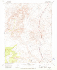
1967 Map of Basalt
USGS Topo · Published 1969About this map
The settlement of Basalt sits at the base of the Candelaria Hills in this 1960s survey of Mineral County. This arid landscape is defined by the remnants of industrial infrastructure and mineral extraction, most notably the long arcs of the Old Railroad Grade and Old RR Grade that traverse the territory. These corridors once connected the region's mining operations to broader markets. Evidence of this extraction economy is visible throughout the hills at the Eastside Mine and Noguez Mine, alongside scattered Gravel Pits and a Mine Dump. A Landing Strip and several Water Tanks represent the necessary adaptations for transport and survival in this high-desert environment, while a network of Jeep Trails provides the primary means of navigating the complex terrain.
Find a feature on this map
15 named features on this map. Tap any name to fly to it.
Don’t see what you’re looking for? This feature index may not catch every label — zoom into the map to look around manually.
Map Details
Editions of this 1967 Basalt Map
4 editions found
Other maps of this area

1909 · Hawthorne
USGS Topo · 1:250,000

1911 · Hawthorne
USGS Topo · 1:250,000

1915 · Hawthorne
USGS Topo · 1:250,000

1917 · White Mountain
USGS Topo · 1:125,000

1947 · Mariposa
USGS Topo · 1:250,000

1948 · Walker Lake
USGS Topo · 1:250,000

1948 · Mariposa
USGS Topo · 1:250,000

1957 · Walker Lake
USGS Topo · 1:250,000

1957 · Mariposa
USGS Topo · 1:250,000

1962 · Walker Lake
USGS Topo · 1:250,000