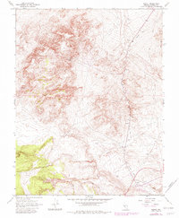
1967 Map of Basalt
USGS Topo · Published 1982About this map
The small outpost of Basalt sits at the junction of desert industry and early transportation networks in this 1967 survey. The landscape is defined by the winding path of the Old Railroad Grade, which skirts the base of the Candelaria Hills and provides a structural anchor for the region's mining and gravel operations. Resource extraction is evident throughout the terrain, from the Eastside Mine to the Naguez Mine, alongside several unidentified mines and a Mine Dump. Infrastructure for the era's light aviation and desert transit is marked by a Landing Strip and multiple Water Tanks, highlighting the logistical challenges of operating in this arid Mineral County environment. Later revisions from 1980 show the persistence of these routes and extraction sites through the late twentieth century.
Find a feature on this map
15 named features on this map. Tap any name to fly to it.
Don’t see what you’re looking for? This feature index may not catch every label — zoom into the map to look around manually.
Map Details
Editions of this 1967 Basalt Map
4 editions found
Other maps of this area

1909 · Hawthorne
USGS Topo · 1:250,000

1911 · Hawthorne
USGS Topo · 1:250,000

1915 · Hawthorne
USGS Topo · 1:250,000

1917 · White Mountain
USGS Topo · 1:125,000

1947 · Mariposa
USGS Topo · 1:250,000

1948 · Walker Lake
USGS Topo · 1:250,000

1948 · Mariposa
USGS Topo · 1:250,000

1957 · Walker Lake
USGS Topo · 1:250,000

1957 · Mariposa
USGS Topo · 1:250,000

1962 · Walker Lake
USGS Topo · 1:250,000