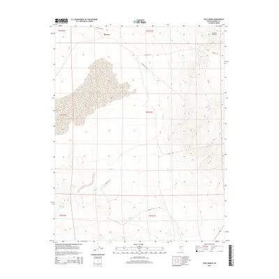
2014 Map of Teels Marsh
USGS Topo · Published 2014About this map
Marietta sits at the northern edge of this high-desert landscape in Mineral County, overlooking the expansive alkaline flats of Teels Marsh. This 2014 survey documents a region defined by its sparse water sources and topographic extremes, where the terrain rises sharply from the marsh floor into the heights of the Excelsior Mountains to the northeast. Historical access to this remote mining and ranching district is traced through a network of unpaved routes, including Garfield Flat Rd, Douglas Rd, and Marietta Rd. Water, the most critical resource in this arid basin, is marked by scattered points such as Company Spring, Rock House Spring, and German Spring. The map clearly illustrates the transition from the flat, salt-crusted basin of the marsh to the complex drainage patterns and canyons of the surrounding mountains, providing a precise look at the township and range divisions across this portion of the Great Basin.
Find a feature on this map
16 named features on this map. Tap any name to fly to it.
Don’t see what you’re looking for? This feature index may not catch every label — zoom into the map to look around manually.
Map Details
Editions of this 2014 Teels Marsh Map
This is the sole edition of this map. No revisions or reprints were ever made.
Other maps of this area

1909 · Hawthorne
USGS Topo · 1:250,000

1911 · Hawthorne
USGS Topo · 1:250,000

1915 · Hawthorne
USGS Topo · 1:250,000

1948 · Walker Lake
USGS Topo · 1:250,000

1957 · Walker Lake
USGS Topo · 1:250,000

1962 · Walker Lake
USGS Topo · 1:250,000

1964 · Walker Lake
USGS Topo · 1:250,000
1967 · Miller Mountain
USGS Topo · 1:24,000

1967 · Moho Mountain
USGS Topo · 1:24,000
1967 · Basalt
USGS Topo · 1:24,000