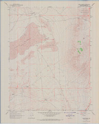
1967 Map of Teels Marsh
USGS Topo · Published 1969About this map
Marietta stands as the primary outpost on the northern fringe of this arid landscape, accompanied by a small Cem and a Landing Strip during the late 1960s. The geography is dominated by the vast Teels Marsh (Depression), a low-lying basin framed by shifting Sand Dunes and the rising slopes of the Excelsior Mountains.
Find a feature on this map
16 named features on this map. Tap any name to fly to it.
Don’t see what you’re looking for? This feature index may not catch every label — zoom into the map to look around manually.
Map Details
Editions of this 1967 Teels Marsh Map
2 editions found
Other maps of this area

1909 · Hawthorne
USGS Topo · 1:250,000

1911 · Hawthorne
USGS Topo · 1:250,000

1915 · Hawthorne
USGS Topo · 1:250,000

1948 · Walker Lake
USGS Topo · 1:250,000

1957 · Walker Lake
USGS Topo · 1:250,000

1962 · Walker Lake
USGS Topo · 1:250,000

1964 · Walker Lake
USGS Topo · 1:250,000
1967 · Miller Mountain
USGS Topo · 1:24,000

1967 · Moho Mountain
USGS Topo · 1:24,000
1967 · Basalt
USGS Topo · 1:24,000