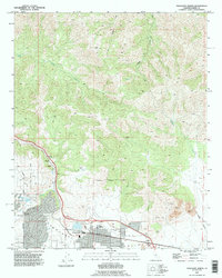
1992 Map of Tehachapi North
USGS Topo · Published 1995About this map
Tehachapi and its surrounding mountain passes are depicted here during the early 1990s, illustrating a landscape defined by its vital transportation and industrial corridors. The Southern Pacific RR winds through the valley, passing through Cable and up toward Summit, tracing the difficult grades that have long characterized this route through the mountains. To the west, Old Town marks the earlier center of settlement, while modern infrastructure like the Tehachapi Municipal Airport and a Golf Course near Tom Sawyer Lake show the town's late-century development.
Find a feature on this map
36 named features on this map. Tap any name to fly to it.
Don’t see what you’re looking for? This feature index may not catch every label — zoom into the map to look around manually.
Map Details
Editions of this 1992 Tehachapi North Map
This is the sole edition of this map. No revisions or reprints were ever made.
Other maps of this area

1914 · Caliente
USGS Topo · 1:125,000

1915 · Mojave
USGS Topo · 1:125,000

1943 · Tehachapi
USGS Topo · 1:62,500

1943 · Emerald Mtn
USGS Topo · 1:62,500

1943 · Cummings Mountain
USGS Topo · 1:62,500

1943 · Breckenridge Mountain
USGS Topo · 1:62,500

1948 · Bakersfield
USGS Topo · 1:250,000

1955 · Bakersfield
USGS Topo · 1:250,000

1956 · Bakersfield
USGS Topo · 1:250,000

1960 · Bakersfield
USGS Topo · 1:250,000