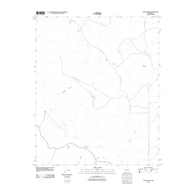
2010 Map of Tejana Mesa
USGS Topo · Published 2010About this map
Chavez Ranch and Mesa Ranch sit within a high desert landscape defined by ephemeral watercourses and dramatic landforms in this 2010 survey. The area is dominated by the broad plateau of Tejana Mesa, which is flanked by the winding drainage of Tejana Draw to the north and the westward flow of Largo Creek to the south.
Find a feature on this map
14 named features on this map. Tap any name to fly to it.
Don’t see what you’re looking for? This feature index may not catch every label — zoom into the map to look around manually.
Map Details
Editions of this 2010 Tejana Mesa Map
This is the sole edition of this map. No revisions or reprints were ever made.
Other maps of this area

1954 · Saint Johns
USGS Topo · 1:250,000

1957 · Saint Johns
USGS Topo · 1:250,000

1958 · Saint Johns
USGS Topo · 1:250,000

1962 · Saint Johns
USGS Topo · 1:250,000

1967 · Mariano Springs
USGS Topo · 1:24,000

1967 · Quemado
USGS Topo · 1:24,000
1967 · Techado
USGS Topo · 1:24,000

1972 · Lake Armijo
USGS Topo · 1:24,000

1972 · Tejana Mesa
USGS Topo · 1:24,000
1972 · Cerro Prieto
USGS Topo · 1:24,000