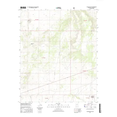
2017 Map of Tejana Mesa SW
USGS Topo · Published 2017About this map
Apache National Forest lands anchor the southeastern portion of this landscape, where the high-altitude terrain is defined by dramatic volcanic features and deep drainage systems. The prominent peak of Cerro Pomo rises in the northwest, serving as a significant topographical landmark overlooking the surrounding high desert plateaus. The map details a remote network of interior canyons, most notably Cottonwood Canyon, which cuts through the central sections of the survey. Transportation in this corner of Catron County is limited to a handful of established thoroughfares, including Catron Co Rd A015 and Box Lake Rd. These roads follow natural contours, connecting isolated ranching lands and forest boundaries. The survey provides a clear view of the complex public land grid, spanning townships t2n r18w and t1n r17w, reflecting the area's history of cattle grazing and land management.
Find a feature on this map
12 named features on this map. Tap any name to fly to it.
Don’t see what you’re looking for? This feature index may not catch every label — zoom into the map to look around manually.
Map Details
Editions of this 2017 Tejana Mesa SW Map
This is the sole edition of this map. No revisions or reprints were ever made.
Other maps of this area

1954 · Saint Johns
USGS Topo · 1:250,000
1955 · Red Hill
USGS Topo · 1:24,000

1957 · Saint Johns
USGS Topo · 1:250,000

1958 · Saint Johns
USGS Topo · 1:250,000

1962 · Saint Johns
USGS Topo · 1:250,000
1972 · Zuni Salt Lake
USGS Topo · 1:24,000
1972 · Lake Armijo
USGS Topo · 1:24,000
1972 · Red Hill
USGS Topo · 1:24,000
1972 · Tejana Mesa
USGS Topo · 1:24,000
1972 · Blaines Lake
USGS Topo · 1:24,000