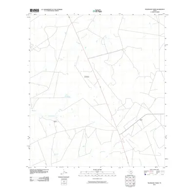
2010 Map of Telephone Tanks
USGS Topo · Published 2010About this map
Las Raices Creek and Cuchara Creek wind through this stretch of South Texas ranch land in Webb County. The landscape is defined by its wide, open cattle country and the sparse but vital infrastructure that supports it. Private holdings such as Brewster Ranch and Bennet Ranch are linked by a network of dirt roads and paths that traverse the drainage basins of Cochio Creek and Jaboncillo Creek. A notable landmark in this remote territory is the La Esperanza Ranch Airport, indicating the reliance on private aviation for access and transport across these expansive acreage blocks. The drainage patterns shown here reflect the seasonal hydrology of the brush country, where intermittent watercourses shape the movement of people and livestock.
Find a feature on this map
7 named features on this map. Tap any name to fly to it.
Don’t see what you’re looking for? This feature index may not catch every label — zoom into the map to look around manually.
Map Details
Editions of this 2010 Telephone Tanks Map
This is the sole edition of this map. No revisions or reprints were ever made.
Other maps of this area
1929 · Cotulla
USGS Topo · 1:125,000
1940 · Velenzuela Creek
USGS Topo · 1:62,500

1953 · Crystal City
USGS Topo · 1:250,000

1955 · Crystal City
USGS Topo · 1:250,000
1956 · Las Tiendas
USGS Topo · 1:62,500
1956 · Webb
USGS Topo · 1:62,500

1956 · Laredo
USGS Topo · 1:250,000
1957 · Encinal
USGS Topo · 1:62,500
1961 · Crystal City
USGS Topo · 1:250,000
1965 · Spohn Ranch
USGS Topo · 1:24,000