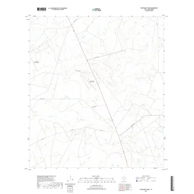
2019 Map of Telephone Tanks
USGS Topo · Published 2019About this map
Las Raices Cr and Cuchara Cr thread through this South Texas landscape, defining a region dominated by ranching interests and private aviation. The terrain is marked by a network of ranch access roads, including Ranch Rd 6238A and Galvan Rd, which connect the remote properties typical of Webb County. Notable aviation markers like Bella Vista Ranch Airport and La Esperanza Ranch Airport indicate the importance of air travel for managing these large landholdings. Further south, Cochio Cr and Jaboncillo Cr cross the arid plains, illustrating the drainage patterns that have historically shaped local land use and boundaries in this part of the state.
Find a feature on this map
14 named features on this map. Tap any name to fly to it.
Don’t see what you’re looking for? This feature index may not catch every label — zoom into the map to look around manually.
Map Details
Editions of this 2019 Telephone Tanks Map
This is the sole edition of this map. No revisions or reprints were ever made.
Other maps of this area
1929 · Cotulla
USGS Topo · 1:125,000
1940 · Velenzuela Creek
USGS Topo · 1:62,500

1953 · Crystal City
USGS Topo · 1:250,000

1955 · Crystal City
USGS Topo · 1:250,000
1956 · Las Tiendas
USGS Topo · 1:62,500
1956 · Webb
USGS Topo · 1:62,500

1956 · Laredo
USGS Topo · 1:250,000
1957 · Encinal
USGS Topo · 1:62,500
1961 · Crystal City
USGS Topo · 1:250,000
1965 · Spohn Ranch
USGS Topo · 1:24,000