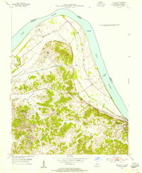
1953 Map of Tell City
USGS Topo · Published 1955About this map
The Ohio River bend dominates this mid-century portrait of the border between Kentucky and Indiana, where river traffic and rail infrastructure converge at Hawesville. The landscape transitions from the broad floodplains of Muddy Gut to the dissected uplands of Hancock County, characterized by the winding valleys of Lead Creek and the North Fork Yellow Creek. Evidence of local industry is clear in the south, where Strip Mines are carved into the hillsides near Butchers Branch and Driskell Branch.
Find a feature on this map
28 named features on this map. Tap any name to fly to it.
Don’t see what you’re looking for? This feature index may not catch every label — zoom into the map to look around manually.
Map Details
Editions of this 1953 Tell City Map
2 editions found
Other maps of this area

1900 · St Meinrad
USGS Topo · 1:62,500

1903 · St. Meinrad
USGS Topo · 1:62,500

1903 · Tell City
USGS Topo · 1:62,500

1934 · Cannelton
USGS Topo · 1:62,500

1949 · Cannelton
USGS Topo · 1:24,000

1953 · Cannelton
USGS Topo · 1:24,000

1953 · Lewisport
USGS Topo · 1:24,000

1953 · Cloverport
USGS Topo · 1:24,000

1953 · Tell City
USGS Topo · 1:24,000
1953 · Maceo
USGS Topo · 1:24,000