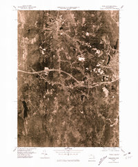
1975 Map of Templeton
USGS Topo · Published 1981About this map
Baldwinville and the winding Otter River define the northern corridor of this 1970s orthophotoquad, which captures the Worcester County landscape through high-altitude aerial imagery. This specific format replaces traditional topographic lines with a rectified photographic view, allowing researchers to see the exact footprint of industrial and residential development during the mid-seventies. In the central region, the town of Templeton sits near the interchange of major local highways, while the western edge is dominated by the sprawling waters of the Birch Hill Reservoir. Further south, the landscape transitions toward the more secluded Goulding Village and the clear boundaries of Queen Lake, illustrating the varied land use between dense woodland and established mill towns. The inclusion of the Burnshirt River drainage provides a detailed look at the watershed patterns that have long influenced the region's geography and settlement.
Find a feature on this map
9 named features on this map. Tap any name to fly to it.
Don’t see what you’re looking for? This feature index may not catch every label — zoom into the map to look around manually.
Map Details
Editions of this 1975 Templeton Map
This is the sole edition of this map. No revisions or reprints were ever made.
Other maps of this area

1885 · Worcester
USGS Topo · 1:62,500

1886 · Worcester
USGS Topo · 1:62,500

1887 · Winchendon
USGS Topo · 1:62,500

1887 · Barre
USGS Topo · 1:62,500

1887 · Fitchburg
USGS Topo · 1:62,500

1889 · Fitchburg
USGS Topo · 1:62,500

1889 · Barre
USGS Topo · 1:62,500

1890 · Winchendon
USGS Topo · 1:62,500

1892 · Worcester
USGS Topo · 1:62,500

1893 · Fitchburg
USGS Topo · 1:62,500