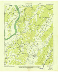
1936 Map of Ten Mile
USGS Topo · Published 1936About this map
Tennessee River waters dominate the western edge of this mid-1930s landscape, winding past Morris Island and Half Moon Island just before the major hydroelectric transformations of the era. The terrain is defined by the prominent Ten Mile Ridge and Hurricane Ridge, which shelter the rural community of Ten Mile PO. This survey, compiled from aerial photographs, illustrates a settled landscape of small upland farms and community hubs centered on local institutions like Cross Keys and Hornsby Chapel. The map reveals a high density of rural infrastructure, including the Ten Mile Sch and Mary Crabtree Sch, alongside numerous family burial grounds such as Baldwin Cem and Mc Caleb Cem. The Tennessee Valley Authority's influence is already visible through the prominent Tennessee Valley Authority Transmission Line cutting across the ridges.
Find a feature on this map
46 named features on this map. Tap any name to fly to it.
Don’t see what you’re looking for? This feature index may not catch every label — zoom into the map to look around manually.
Map Details
Editions of this 1936 Ten Mile Map
This is the sole edition of this map. No revisions or reprints were ever made.
Other maps of this area

1887 · Kingston
USGS Topo · 1:125,000

1891 · Kingston
USGS Topo · 1:125,000

1893 · Kingston
USGS Topo · 1:125,000

1935 · Niota
USGS Topo · 1:24,000

1935 · Rockwood
USGS Topo · 1:24,000

1935 · Decatur
USGS Topo · 1:24,000

1936 · Roddy
USGS Topo · 1:24,000

1936 · Spring City
USGS Topo · 1:24,000
1936 · Pattie Gap
USGS Topo · 1:24,000
1936 · Tranquillity
USGS Topo · 1:24,000