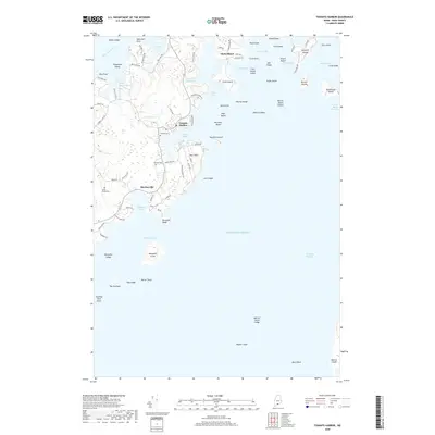
2018 Map of Tenants Harbor
USGS Topo · Published 2018About this map
The sheltered waters of Tenants Harbor and Mosquito Harbor anchor this coastal survey, where the seafaring tradition of Knox County meets the granite-bound shores of the Atlantic Ocean. The settlement pattern follows the intricate coastline, with clusters of homes and docks in Martinsville and around the cove at Tenants Harbor. Local genealogy is well-preserved through the documentation of the Seaside Cemetery, Hillside Cemetery, and South Parish Cemetery, providing fixed points for historical research. Beyond the mainland, the map details a dense archipelago including Clark Island, Whitehead Island, and Mosquito Island, many of which are connected to the maritime industry by ledges and shoals like Mosquito Ledge and Hart Ledge. This 2018 edition illustrates how modern road networks like Ridge Road and Harts Neck Road navigate the same peninsulas and points that have defined this harbor community for generations.
Find a feature on this map
94 named features on this map. Tap any name to fly to it.
Don’t see what you’re looking for? This feature index may not catch every label — zoom into the map to look around manually.
Map Details
Editions of this 2018 Tenants Harbor Map
This is the sole edition of this map. No revisions or reprints were ever made.
Other maps of this area

1904 · Monhegan
USGS Topo · 1:62,500

1904 · Tenants Harbor
USGS Topo · 1:62,500

1904 · Rockland
USGS Topo · 1:62,500

1906 · Tennant Harbor
USGS Topo · 1:62,500

1906 · Monhegan
USGS Topo · 1:62,500

1906 · Rockland
USGS Topo · 1:62,500

1913 · Waldoboro
USGS Topo · 1:48,000

1915 · Waldoboro
USGS Topo · 1:62,500

1941 · Rockland
USGS Topo · 1:62,500

1941 · Waldoboro
USGS Topo · 1:62,500