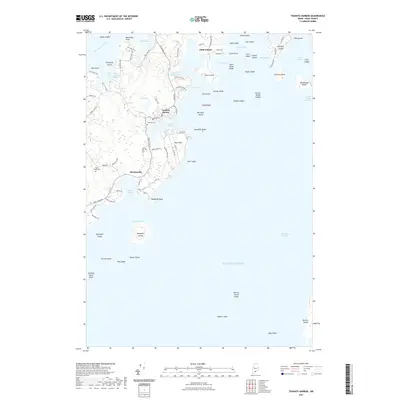
2021 Map of Tenants Harbor
USGS Topo · Published 2021About this map
Tenants Harbor serves as the central hub of this Knox County coastline, where the rugged maritime geography of the Saint George peninsula meets the Atlantic. The map documents a complex network of coastal roads like St George Rd and Port Clyde Rd that connect the village to outlying settlements at Martinsville and Clark Island. Beyond the mainland, the map details an intricate archipelago including Whitehead Island, Rackliff Island, and the Spectacles, defining the navigational hazards and sheltered waters of Wheeler Bay and the Muscle Ridge Channel. For the local historian, the inclusion of several burial grounds, such as Seaside Cem and South Parish Cem, provides essential points of reference for genealogical research. The landscape is characterized by its tidal features and named points, from Hawthorn Point in the north down to the prominent Mosquito Head at the southern tip of the harbor's protection.
Find a feature on this map
97 named features on this map. Tap any name to fly to it.
Don’t see what you’re looking for? This feature index may not catch every label — zoom into the map to look around manually.
Map Details
Editions of this 2021 Tenants Harbor Map
This is the sole edition of this map. No revisions or reprints were ever made.
Other maps of this area

1904 · Monhegan
USGS Topo · 1:62,500

1904 · Tenants Harbor
USGS Topo · 1:62,500

1904 · Rockland
USGS Topo · 1:62,500

1906 · Tennant Harbor
USGS Topo · 1:62,500

1906 · Monhegan
USGS Topo · 1:62,500

1906 · Rockland
USGS Topo · 1:62,500

1913 · Waldoboro
USGS Topo · 1:48,000

1915 · Waldoboro
USGS Topo · 1:62,500

1941 · Rockland
USGS Topo · 1:62,500

1941 · Waldoboro
USGS Topo · 1:62,500