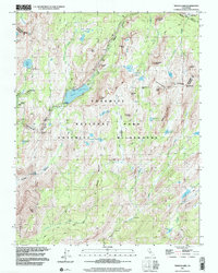
1997 Map of Tenaya Lake
USGS Topo · Published 2002About this map
Tenaya Lake serves as the focal point for this survey of the high country, where the granite landscape of the Cathedral Range meets a dense network of glacial basins. The map documents the infrastructure of high-altitude recreation in the late 20th century, notably featuring the May Lake High Sierra Camp and the Sunrise High Sierra Camp, which provide remote lodging far from the primary road corridors. The transportation through this wilderness is defined by the winding path of Tioga Road and the intersection of the John Muir Trail as it crosses Meadow and follows the Cathedral Fork.
Find a feature on this map
51 named features on this map. Tap any name to fly to it.
Don’t see what you’re looking for? This feature index may not catch every label — zoom into the map to look around manually.
Map Details
Editions of this 1997 Tenaya Lake Map
This is the sole edition of this map. No revisions or reprints were ever made.
Other maps of this area

1897 · Yosemite
USGS Topo · 1:125,000

1900 · Yosemite
USGS Topo · 1:125,000

1901 · Mt. Lyell
USGS Topo · 1:125,000

1903 · Yosemite
USGS Topo · 1:125,000

1909 · Yosemite
USGS Topo · 1:125,000

1947 · Mariposa
USGS Topo · 1:250,000

1948 · Mariposa
USGS Topo · 1:250,000

1953 · Merced Peak
USGS Topo · 1:62,500

1956 · Hetch Hetchy Reservoir
USGS Topo · 1:62,500

1956 · Tuolumne Meadows
USGS Topo · 1:62,500