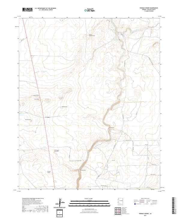
2021 Map of Tenmile Cedars
USGS Topo · Published 2021About this map
Tenmile Cedars and the nearby settlement of Cañoncito anchor this portion of Navajo County, where the landscape is defined by the drainage network of the Little Colorado River. Water management is central to the area's development, evidenced by the Woodruff Ditch and the Woodruff Reservoir in the northern section. These irrigation features stand in contrast to the arid surroundings marked by named landmarks like Bishops Nose and The Divide. The terrain is characterized by a series of draws and hills, including Arthurs Meadow Draw, Tenmile Draw, and Graveled Hill. A network of unpaved tracks and local roads like Old Woodruff Rd and Reipel Rd connect scattered water tanks such as Cottonwood Tank and Louis Hunt Tank, reflecting the ranching infrastructure typical of the Arizona high desert.
Find a feature on this map
38 named features on this map. Tap any name to fly to it.
Don’t see what you’re looking for? This feature index may not catch every label — zoom into the map to look around manually.
Map Details
Editions of this 2021 Tenmile Cedars Map
This is the sole edition of this map. No revisions or reprints were ever made.
Other maps of this area

1886 · St Johns
USGS Topo · 1:250,000

1886 · Holbrook
USGS Topo · 1:250,000

1892 · St Johns
USGS Topo · 1:250,000

1893 · Holbrook
USGS Topo · 1:250,000

1912 · Petrified Forest
USGS Topo · 1:62,500

1954 · Holbrook
USGS Topo · 1:250,000

1954 · Saint Johns
USGS Topo · 1:250,000

1955 · Petrified Forest
USGS Topo · 1:62,500

1955 · St. Joseph 1 SE
USGS Topo · 1:24,000
1955 · Holbrook
USGS Topo · 1:62,500