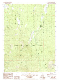
1988 Map of Tennant
USGS Topo · Published 1988About this map
The timber and transit town of Tennant sits at the heart of this late-1980s landscape, serving as a hub for the surrounding mountainous terrain. The map records the remnants of a significant rail-based economy, specifically the O.W.R.R. Grade and other unnamed Railroad Grades that snake through the forest, indicating the historical movement of timber from the heights of Haight Mountain and Picadilly Ridge. The infrastructure of the Klamath National Forest is well-established, featuring the Tennant F.S. Station, a Gaging Station, and a designated Landing Strip central to forest management.
Find a feature on this map
26 named features on this map. Tap any name to fly to it.
Don’t see what you’re looking for? This feature index may not catch every label — zoom into the map to look around manually.
Map Details
Editions of this 1988 Tennant Map
This is the sole edition of this map. No revisions or reprints were ever made.
Other maps of this area

1886 · Modoc Lava Bed
USGS Topo · 1:250,000

1886 · Shasta
USGS Topo · 1:250,000

1892 · Modoc Lava-Bed
USGS Topo · 1:250,000

1894 · Shasta
USGS Topo · 1:250,000

1932 · Bartle
USGS Topo · 1:96,000

1934 · Macdoel
USGS Topo · 1:96,000

1935 · Dunsmuir
USGS Topo · 1:125,000

1939 · Bartle
USGS Topo · 1:125,000

1941 · Macdoel
USGS Topo · 1:125,000

1948 · Weed
USGS Topo · 1:250,000