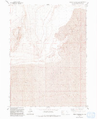
1991 Map of Terrace Mountain East
USGS Topo · Published 1991About this map
Terrace Mountain dominates the western edge of this Box Elder County landscape, its steep contours rising sharply from the surrounding basins. This 1991 revision, based on aerial photography from the late 1980s, captures a stark, unpopulated expanse where the high desert meets the extensive salt flats and playas characteristic of the region. The map is defined by the vast area labeled simply as Mud, representing the ephemeral lake beds and saturated alkaline soils that spread across the eastern and southern portions of the quadrangle. The lack of infrastructure, settlements, or even unimproved roads throughout the central sections of this survey suggests a terrain that remains largely impassable or restricted by the harsh environmental conditions of the Great Salt Lake Desert basin.
Find a feature on this map
3 named features on this map. Tap any name to fly to it.
Don’t see what you’re looking for? This feature index may not catch every label — zoom into the map to look around manually.
Map Details
Editions of this 1991 Terrace Mountain East Map
This is the sole edition of this map. No revisions or reprints were ever made.
Other maps of this area

1954 · Brigham City
USGS Topo · 1:250,000

1958 · Brigham City
USGS Topo · 1:250,000

1962 · Brigham City
USGS Topo · 1:250,000

1971 · Prohibition Spring
USGS Topo · 1:24,000

1971 · Red Dome
USGS Topo · 1:24,000

1971 · Matlin
USGS Topo · 1:24,000

1983 · Lemay
USGS Topo · 1:24,000

1983 · Bovine SE
USGS Topo · 1:24,000

1983 · Terrace Mountain West
USGS Topo · 1:24,000

1983 · Terrace Mountain East
USGS Topo · 1:24,000