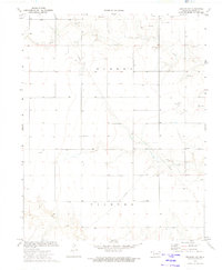
1973 Map of Texhoma NW
USGS Topo · Published 1975About this map
Tepee Creek and its various tributaries meander through this section of the Oklahoma Panhandle, illustrating a landscape defined by ranching and resource extraction in the early 1970s. The map shows the Oil and Gas Field northwest of Clark Landing Field, marked by numerous Oil Wells and a Drill Hole. This energy infrastructure is supported by a network of pipelines crossing the survey area. For those researching local family history or land use, the Baker Cem stands as a significant point of interest amidst the expansive Turney and Texhoma sections. The terrain is further characterized by surface mining operations, including a Caliche Pit and several Gravel Pits, which indicate the local economic reliance on both the geology below and the cattle country above. The sparse road network and scattered landmarks suggest a low-density rural community centered on these vital industries.
Find a feature on this map
17 named features on this map. Tap any name to fly to it.
Don’t see what you’re looking for? This feature index may not catch every label — zoom into the map to look around manually.
Map Details
Editions of this 1973 Texhoma NW Map
This is the sole edition of this map. No revisions or reprints were ever made.
Other maps of this area

1954 · Perryton
USGS Topo · 1:250,000

1954 · Dalhart
USGS Topo · 1:250,000

1958 · Perryton
USGS Topo · 1:250,000

1958 · Dalhart
USGS Topo · 1:250,000

1962 · Dalhart
USGS Topo · 1:250,000

1971 · Griggs NE
USGS Topo · 1:24,000

1971 · Griggs
USGS Topo · 1:24,000

1971 · Hopkins
USGS Topo · 1:24,000

1973 · Texhoma NE
USGS Topo · 1:24,000

1973 · Texhoma North
USGS Topo · 1:24,000