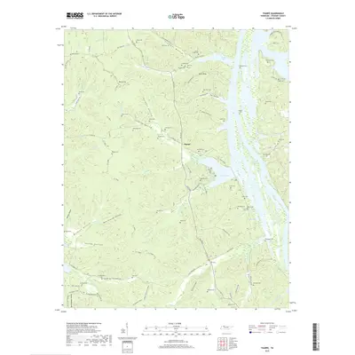
2019 Map of Tharpe
USGS Topo · Published 2019About this map
Tharpe and the surrounding woodlands of Stewart County are defined by a complex network of hollows and ridges adjacent to Lake Barkley. This 2019 survey documents a landscape preserved through extensive land management, where the historic thoroughfare of The Trace bisects the terrain. The map is exceptionally valuable for genealogical research, identifying numerous family burial sites such as Byrd Cem, Pettit Cem, and Hill Top Cem that are tucked into the drainages of Crutcher Hollow and Burgess Hollow.
Find a feature on this map
100 named features on this map. Tap any name to fly to it.
Don’t see what you’re looking for? This feature index may not catch every label — zoom into the map to look around manually.
Map Details
Editions of this 2019 Tharpe Map
This is the sole edition of this map. No revisions or reprints were ever made.
Other maps of this area

1936 · Tharpe
USGS Topo · 1:24,000

1936 · Hamlin
USGS Topo · 1:24,000

1936 · Centerville Landing
USGS Topo · 1:24,000

1936 · Rushing
USGS Topo · 1:24,000

1936 · Standing Rock
USGS Topo · 1:24,000

1936 · Dover
USGS Topo · 1:24,000

1950 · Rushing Creek
USGS Topo · 1:24,000
1950 · Paris Landing
USGS Topo · 1:24,000

1950 · Standing Rock
USGS Topo · 1:24,000
1950 · Hamlin
USGS Topo · 1:24,000