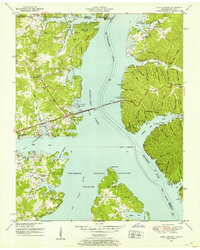
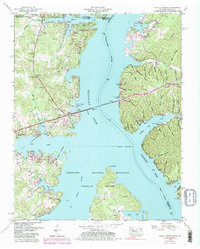
1950 Map of Paris Landing
USGS Topo · Published 1953About this map
Kentucky Lake dominates this 1950 survey, showing the landscape of West Tennessee shortly after the completion of the Kentucky Dam. The water has filled the Tennessee River valley, creating the intricate shoreline of bays and hollows that define Paris Landing State Park. This era of transition is marked by the presence of a U S Coast Guard Base and the Scott Fitzhugh Bridge carrying the Austin Peay Memorial Highway across the wide expanse. Inland, the map remains a record of established rural life, dotted with numerous family cemeteries and country churches. Genealogists can trace family names through landmarks like Scarbrough Cem, Ratleeree Cem, and Hephzibah Ch. The southern portion of the sheet is largely dedicated to the Tennessee National Migratory Wildlife Refuge, preserving the bottomlands where the Big Sandy River meets the main channel.
Find a feature on this map
85 named features on this map. Tap any name to fly to it.
Don’t see what you’re looking for? This feature index may not catch every label — zoom into the map to look around manually.
Map Details
Editions of this 1950 Paris Landing Map
5 editions found
Other maps of this area

1936 · Poplar Creek
USGS Topo · 1:24,000

1936 · Buchanan
USGS Topo · 1:24,000

1936 · Tharpe
USGS Topo · 1:24,000

1936 · New Concord
USGS Topo · 1:24,000

1936 · McKinnon
USGS Topo · 1:24,000

1936 · Hamlin
USGS Topo · 1:24,000

1936 · Centerville Landing
USGS Topo · 1:24,000

1936 · Standing Rock
USGS Topo · 1:24,000

1936 · Springville
USGS Topo · 1:24,000

1938 · Springville
USGS Topo · 1:24,000