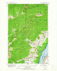
1947 Map of The Brothers
USGS Topo · Published 1964About this map
The Dosewallips River and Duckabush River systems carve through the heart of the Olympic Peninsula, anchored by the towering peaks of The Brothers and Mt Jupiter. In the late 1940s, this region of Olympic National Park was characterized by a network of backcountry shelters and camps such as Nine-mile Camp and Tenmile Shelter, supporting forest management and early recreation. To the east, the landscape meets the saltwater of the Hood Canal, where the small settlement of Eldon and the John Ahl Sch mark the localized pocket of coastal development. The map reveals the infrastructure of resource protection in a roadless era, noting the Webb Lookout and the Hamma Hamma Guard Sta, which served as critical nodes for monitoring the vast timberlands between Jefferson Creek and Fulton Creek.
Find a feature on this map
63 named features on this map. Tap any name to fly to it.
Don’t see what you’re looking for? This feature index may not catch every label — zoom into the map to look around manually.
Map Details
Editions of this 1947 The Brothers Map
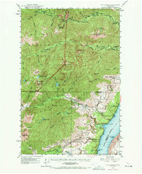
Other maps of this area

1936 · Point Misery
USGS Topo · 1:62,500

1938 · Mt Constance
USGS Topo · 1:125,000

1938 · Allyn
USGS Topo · 1:62,500

1940 · Point Misery
USGS Topo · 1:62,500

1940 · Quilcene
USGS Topo · 1:62,500

1943 · Potlatch
USGS Topo · 1:62,500

1944 · Mt. Angeles
USGS Topo · 1:62,500

1946 · Mt. Angeles
USGS Topo · 1:62,500

1946 · Tyler Peak
USGS Topo · 1:62,500

1947 · The Brothers
USGS Topo · 1:62,500