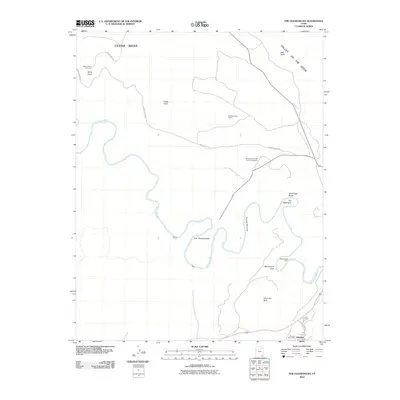
2010 Map of The Goosenecks
USGS Topo · Published 2010About this map
The Goosenecks of the San Juan River dominate this desert landscape, where the water has carved deep, symmetrical meanders through the colorful strata. This high-desert plateau, part of Cedar Mesa, contains isolated markers of human presence like the Raplees Stone House and Mendenhalls Cabin, indicating a history of hardy settlement in a challenging environment. Near the southern edge, the community of Halchita and the Mexican Post Office serve as modern anchors close to the river's path. The map details a geography defined by dramatic verticality, from the high Muley Point Overlook to the low Second Narrows. Notable landmarks such as Alhambra Rock and Bell Butte stand as sentinels across the Valley of the Gods, illustrating the erosion patterns that characterize the Four Corners region.
Find a feature on this map
23 named features on this map. Tap any name to fly to it.
Don’t see what you’re looking for? This feature index may not catch every label — zoom into the map to look around manually.
Map Details
Editions of this 2010 The Goosenecks Map
This is the sole edition of this map. No revisions or reprints were ever made.
Other maps of this area

1886 · Henry Mountains
USGS Topo · 1:250,000

1886 · Abajo
USGS Topo · 1:250,000

1892 · Abajo
USGS Topo · 1:250,000

1892 · Henry Mountains
USGS Topo · 1:250,000

1893 · Abajo
USGS Topo · 1:250,000

1952 · Bluff 3 SE
USGS Topo · 1:24,000

1952 · Clay Hills 4 SE
USGS Topo · 1:24,000
1952 · Bluff 3 SW
USGS Topo · 1:24,000

1956 · Escalante
USGS Topo · 1:250,000

1956 · Cortez
USGS Topo · 1:250,000