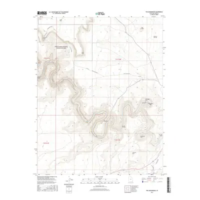
2017 Map of The Goosenecks
USGS Topo · Published 2017About this map
The entrenched meanders of the San Juan River dominate this desert landscape, forming the dramatic geologic features known as The Goosenecks. This reach of the river includes distinctive landmarks such as the Mendenhall Loop and the Second Narrows, where the water has carved deep into the layers of the Cedar Mesa. To the east, the small settlement of Mexican Hat sits near the river crossing, serving as a gateway to the famous monoliths of the Valley of the Gods and Goodridge Rocks.
Find a feature on this map
25 named features on this map. Tap any name to fly to it.
Don’t see what you’re looking for? This feature index may not catch every label — zoom into the map to look around manually.
Map Details
Editions of this 2017 The Goosenecks Map
This is the sole edition of this map. No revisions or reprints were ever made.
Other maps of this area

1886 · Henry Mountains
USGS Topo · 1:250,000

1886 · Abajo
USGS Topo · 1:250,000

1892 · Abajo
USGS Topo · 1:250,000

1892 · Henry Mountains
USGS Topo · 1:250,000

1893 · Abajo
USGS Topo · 1:250,000

1952 · Bluff 3 SE
USGS Topo · 1:24,000

1952 · Clay Hills 4 SE
USGS Topo · 1:24,000
1952 · Bluff 3 SW
USGS Topo · 1:24,000

1956 · Escalante
USGS Topo · 1:250,000

1956 · Cortez
USGS Topo · 1:250,000