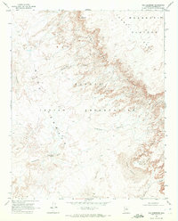
1969 Map of The Landmark
USGS Topo · Published 1972About this map
Navajo Indian Reservation lands dominate this late-1960s survey, characterized by dramatic elevation shifts and wind-sculpted terrain. The namesake feature, The Landmark, rises as a prominent point of orientation above Landmark Wash, while the sprawling Moenkopi Plateau and the sharp drop-offs of the Adeii Eeichi Cliffs define the northeastern portion of the sheet. To the southwest, the relatively level expanse of Ward Terrace eventually gives way to a landscape of moving earth.
Find a feature on this map
15 named features on this map. Tap any name to fly to it.
Don’t see what you’re looking for? This feature index may not catch every label — zoom into the map to look around manually.
Map Details
Editions of this 1969 The Landmark Map
This is the sole edition of this map. No revisions or reprints were ever made.
Other maps of this area

1886 · San Francisco Mtns
USGS Topo · 1:250,000

1891 · San Francisco Mtns
USGS Topo · 1:250,000

1894 · San Francisco Mtns
USGS Topo · 1:250,000

1899 · San Francisco Mtns
USGS Topo · 1:250,000

1947 · Flagstaff
USGS Topo · 1:250,000

1954 · Flagstaff
USGS Topo · 1:250,000

1955 · Black Falls NE
USGS Topo · 1:24,000
1955 · Cameron SE
USGS Topo · 1:24,000

1955 · Cameron
USGS Topo · 1:62,500

1958 · Flagstaff
USGS Topo · 1:250,000