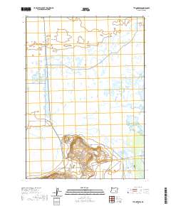
2020 Map of The Narrows
USGS Topo · Published 2020About this map
Malheur Lake dominates this portion of the Harney Basin, where the expansive wetlands and marshes of the High Desert define the human and natural geography. The small settlement of Narrows is located at a critical hydrological bottleneck, known as The Narrows, where water moves between the larger lake system and Mud Lake. This area reflects the essential relationship between water management and ranching in southeastern Oregon, illustrated by the presence of the Rinehart Ditch and Butte Ditch to the south. Transportation in this basin is marked by long, straight ranch roads such as Oo Ranch Rd and Sodhouse Ln, which serve the agricultural community in Sunset Valley. The map details a complex network of seasonal water features, including Vickers Lake and Simmons Slough, showing the landscape as it functioned in the early 21st century.
Find a feature on this map
21 named features on this map. Tap any name to fly to it.
Don’t see what you’re looking for? This feature index may not catch every label — zoom into the map to look around manually.
Map Details
Editions of this 2020 The Narrows Map
This is the sole edition of this map. No revisions or reprints were ever made.
Other maps of this area

1955 · Burns
USGS Topo · 1:250,000

1958 · Burns
USGS Topo · 1:250,000

1959 · Burns
USGS Topo · 1:250,000

1959 · Dog Mountain
USGS Topo · 1:62,500

1959 · Lawen
USGS Topo · 1:62,500

1967 · Coyote Buttes
USGS Topo · 1:24,000

1967 · Jackass Butte NE
USGS Topo · 1:24,000

1978 · Malheur Lake
USGS Topo · 1:100,000
1980 · Southeast Harney Lake
USGS Topo · 1:24,000
1990 · The Narrows
USGS Topo · 1:24,000