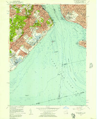
1955 Map of The Narrows
USGS Topo · Published 1957About this map
The Narrows separates the growing suburban residential pockets of Staten Island from the dense grid of Brooklyn in the mid-1950s. On the Richmond side, neighborhoods like Dongan Hills and Grasmere sit between the sprawling Moravian Cemetery and the shoreline, while the Staten Island Rapid Transit line provides a vital spine for commuters heading toward the ferry. The landscape is dotted with academic and religious institutions, from Wagner Memorial College on Grymes Hill to the Academy of St Dorothy, illustrating the mid-century development of the borough's interior.
Find a feature on this map
125 named features on this map. Tap any name to fly to it.
Don’t see what you’re looking for? This feature index may not catch every label — zoom into the map to look around manually.
Map Details
Editions of this 1955 The Narrows Map
2 editions found
Other maps of this area

1888 · Sandy Hook
USGS Topo · 1:62,500

1889 · Brooklyn
USGS Topo · 1:62,500

1891 · Brooklyn
USGS Topo · 1:62,500

1893 · Sandy Hook
USGS Topo · 1:62,500

1897 · Brooklyn
USGS Topo · 1:62,500

1898 · Staten Island
USGS Topo · 1:62,500

1898 · Brooklyn
USGS Topo · 1:62,500

1900 · Passaic
USGS Topo · 1:125,000

1900 · Staten Island
USGS Topo · 1:62,500

1900 · Brooklyn
USGS Topo · 1:62,500