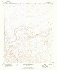
1966 Map of The Pillar 3 NW
USGS Topo · Published 1969About this map
The Navajo Indian Reservation landscape is defined here by the winding course of the Chaco River, which carves a wide, sandy path through the high desert of San Juan County. Mapped in the mid-1960s, the terrain reveals a sparse network of water sources and infrastructure, including Indian Cr and a solitary Well located south of the river bend. This survey represents a specific moment in the mid-century development of the region, where traditional land use and modern utility projects began to intersect. Evidence of industrial expansion into the desert is visible through the presence of a Pipeline cutting across the southeastern corner, illustrating the growing infrastructure required to support resource extraction and transport across these remote reaches of New Mexico.
Find a feature on this map
5 named features on this map. Tap any name to fly to it.
Don’t see what you’re looking for? This feature index may not catch every label — zoom into the map to look around manually.
Map Details
Editions of this 1966 The Pillar 3 NW Map
2 editions found
Other maps of this area

1889 · Chaco
USGS Topo · 1:250,000

1892 · Chaco
USGS Topo · 1:250,000

1927 · Sulphur Spring
USGS Topo · 1:96,000

1928 · Kirtland
USGS Topo · 1:125,000

1932 · Kirtland
USGS Topo · 1:125,000

1954 · Shiprock
USGS Topo · 1:250,000

1958 · Shiprock
USGS Topo · 1:250,000

1959 · Shiprock
USGS Topo · 1:250,000
1966 · Burnham Trading Post
USGS Topo · 1:24,000
1966 · The Pillar 3 NE
USGS Topo · 1:24,000