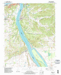
1993 Map of Thebes
USGS Topo · Published 1995About this map
The Mississippi River dominates this landscape where Illinois meets Missouri, carving a wide path past the riverside settlements of Thebes and Commerce. This mid-1990s revision reveals a complex network of river islands and chutes, including Burnham Island and Santa Fe Chute, which reflect the dynamic nature of the waterway. Landward, the St Louis Southwestern RR and Santa Fe lines parallel the bluffs, supporting the industrial and transit character of the river corridor.
Find a feature on this map
53 named features on this map. Tap any name to fly to it.
Don’t see what you’re looking for? This feature index may not catch every label — zoom into the map to look around manually.
Map Details
Editions of this 1993 Thebes Map
This is the sole edition of this map. No revisions or reprints were ever made.
Other maps of this area

1920 · Jonesboro
USGS Topo · 1:62,500

1922 · Cape Girardeau
USGS Topo · 1:62,500

1923 · Jonesboro
USGS Topo · 1:62,500

1924 · Cape Girardeau
USGS Topo · 1:62,500

1934 · Thebes
USGS Topo · 1:62,500

1934 · Morley
USGS Topo · 1:62,500

1939 · Morley
USGS Topo · 1:62,500

1939 · Thebes
USGS Topo · 1:62,500

1947 · Jonesboro
USGS Topo · 1:62,500
1947 · Mc Clure
USGS Topo · 1:24,000