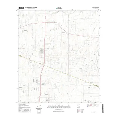
2016 Map of Thelma
USGS Topo · Published 2016About this map
The Medina River defines the northern edge of this landscape, carving through the terrain north of Oak Island. This southern portion of Bexar County transition into Atascosa County is a network of creek drainages, including Gallinas Cr and Galvan Cr, which cut through the various residential developments and rural tracts. The small settlement of Thelma sits at the eastern edge, while Cannon Field serves as a distinct local landmark in the central region.
Find a feature on this map
102 named features on this map. Tap any name to fly to it.
Don’t see what you’re looking for? This feature index may not catch every label — zoom into the map to look around manually.
Map Details
Editions of this 2016 Thelma Map
This is the sole edition of this map. No revisions or reprints were ever made.
Other maps of this area

1953 · Terrell Wells
USGS Topo · 1:24,000

1953 · Macdona
USGS Topo · 1:24,000

1953 · Southton
USGS Topo · 1:24,000

1954 · San Antonio
USGS Topo · 1:250,000

1957 · San Antonio
USGS Topo · 1:250,000

1958 · Losoya
USGS Topo · 1:24,000

1958 · Somerset
USGS Topo · 1:24,000

1958 · Thelma
USGS Topo · 1:24,000

1964 · Leming
USGS Topo · 1:24,000
1967 · Terrell Wells
USGS Topo · 1:24,000