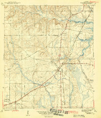
1943 Map of Theodore
USGS Topo · Published 1943About this map
The town of Theodore stands as a central junction for South Mobile County, where the industrial and transport networks of the mid-twentieth century converge. This survey, based on field work by E. R. Batteen and Harold Williams, details the vital transit corridors of the Louisville and Nashville Railroad and the historic Old Spanish Trail. To the west, the St Elmo-Irvington Sch and Cedar Grove Ch serve the rural community near Irvington, while the landscape toward the coast transitions into the marshy reaches of Hollingers Island and Rattlesnake Bayou.
Find a feature on this map
36 named features on this map. Tap any name to fly to it.
Don’t see what you’re looking for? This feature index may not catch every label — zoom into the map to look around manually.
Map Details
Editions of this 1943 Theodore Map
2 editions found

Other maps of this area

1921 · Grand Bay
USGS Topo · 1:62,500

1921 · Delchamps
USGS Topo · 1:62,500

1922 · Mobile
USGS Topo · 1:62,500

1940 · Hollingers Island
USGS Topo · 1:31,680

1940 · Mobile
USGS Topo · 1:31,680

1940 · Mobile
USGS Topo · 1:62,500

1941 · Cedar Point
USGS Topo · 1:62,500

1941 · Hurley
USGS Topo · 1:62,500

1942 · Theodore
USGS Topo · 1:31,680

1943 · Cedar Point
USGS Topo · 1:62,500