
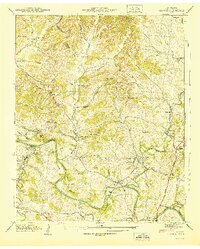
1936 Map of Theta
USGS Topo · Published 1936About this map
Theta and Bending Chestnut anchor this mid-1930s survey of the rural borderlands between Williamson and Maury Counties. The landscape is defined by the Duck River Basin and the winding Duck River Divide, where a network of family-named hollows and creek branches supports a scattered agricultural community. Small-scale rural infrastructure is prominent, including the Morse Spring School and Parham School, alongside numerous country churches like Chestnut Ridge Church and Bethel Church. Local genealogy is well-preserved through detailed cemetery locations such as Carlisle Cem and Lockhart Cem. The absence of heavy industry or large towns highlights the era's reliance on the local terrain, with the Chestnut Ridge forming a natural spine for the area's secondary roads and homesteads.
Find a feature on this map
62 named features on this map. Tap any name to fly to it.
Don’t see what you’re looking for? This feature index may not catch every label — zoom into the map to look around manually.
Map Details
Editions of this 1936 Theta Map
This is the sole edition of this map. No revisions or reprints were ever made.
Other maps of this area

1901 · Colombia
USGS Topo · 1:125,000

1909 · Franklin
USGS Topo · 1:62,500

1936 · Godwin
USGS Topo · 1:24,000

1936 · Williamsport
USGS Topo · 1:24,000

1936 · Primm
USGS Topo · 1:24,000

1936 · Spring Hill
USGS Topo · 1:24,000

1936 · Carters Creek
USGS Topo · 1:24,000

1936 · Craigfield
USGS Topo · 1:24,000

1940 · Godwin
USGS Topo · 1:24,000
1941 · Godwin
USGS Topo · 1:24,000