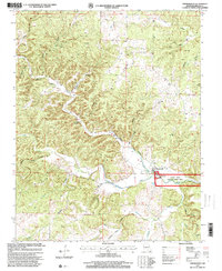
1997 Map of Thomasville
USGS Topo · Published 2000About this map
Thomasville serves as the focal point for this section of the Ozarks, situated at the confluence where the Middle Fork and Barren Fork meet to form the Eleven Point River. This 1997 revision highlights the protected status of the waterway as the Eleven Point Wild and Scenic River, emphasizing its importance for both conservation and recreation. The Thomasville Boat Ramp provides a key access point for river travel, while numerous karst features like Bill Mac Spring and Jolliff Spring feed the clear river system. Evidence of local industry is visible through the Iron Mine and its associated Iron Mine Tailings Pond, providing a record of the area's mineral extraction history. The landscape is characterized by a dense network of timbered valleys such as DePriest Hollow and Wick Cave Hollow, reflecting the traditional settlement patterns of the Missouri hills.
Find a feature on this map
29 named features on this map. Tap any name to fly to it.
Don’t see what you’re looking for? This feature index may not catch every label — zoom into the map to look around manually.
Map Details
Editions of this 1997 Thomasville Map
This is the sole edition of this map. No revisions or reprints were ever made.
Other maps of this area

1931 · Bandyville
USGS Topo · 1:48,000

1943 · Thayer
USGS Topo · 1:62,500

1944 · Couch
USGS Topo · 1:62,500

1944 · Birch Tree
USGS Topo · 1:62,500

1945 · Montier
USGS Topo · 1:62,500

1946 · Thayer
USGS Topo · 1:62,500

1946 · Couch
USGS Topo · 1:62,500

1948 · Montier
USGS Topo · 1:62,500

1948 · Birch Tree
USGS Topo · 1:62,500

1957 · Poplar Bluff
USGS Topo · 1:250,000